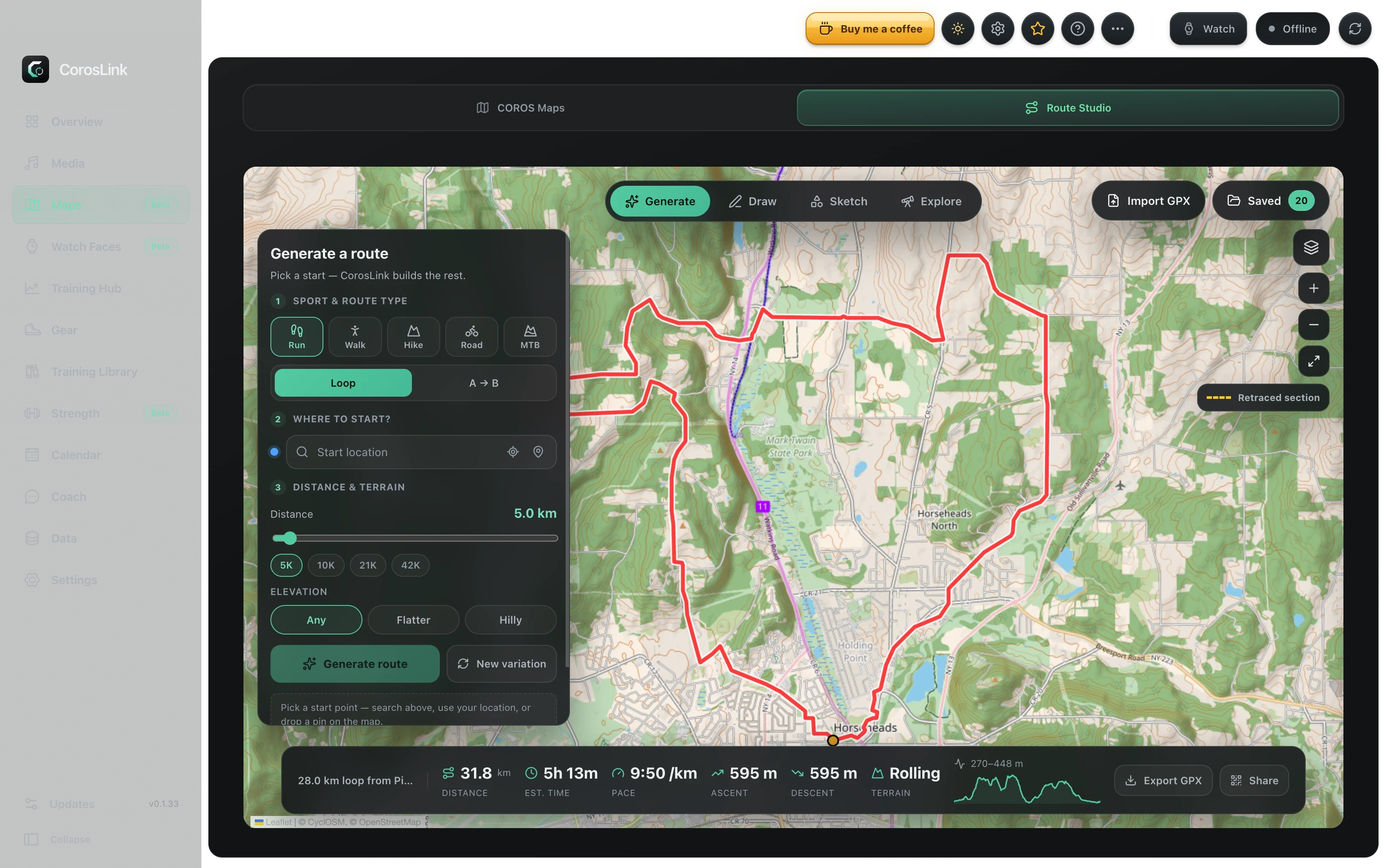
Plan routes for your COROS watch on a real screen.
Draw or generate a route on desktop, check distance and elevation, and export a GPX file your COROS watch can navigate. CorosLink's route builder works with running, walking, hiking, road cycling and mountain biking presets.
Route generation needs a free OpenRouteService API key. Watch navigation depends on your COROS model.
Planning a route on a phone screen is fiddly. CorosLink gives you a full-size interactive map, sport-specific routing and an elevation profile, then hands the finished GPX to your phone with a QR code so you can import it into the COROS app's route library and send it to the watch.
You can also bring in routes you already have. GPX files from Strava, Komoot or any other planner load as saved routes with distance, elevation and loop detection.
Loop or point-to-point routes generated with a free OpenRouteService key
Sport presets for running, walking, hiking, road cycling and mountain biking
Elevation preference to favour flatter or hillier options
Interactive map preview with start pin, fit-to-route and layer themes
Distance, estimated time and pace, ascent, descent and an elevation profile
GPX import and export
Import GPX files from Strava, Komoot or anywhere else. Each one becomes a saved route with stats and a preview. Export any route as GPX, or share it to your phone with a QR code for import into the COROS mobile app.
Getting the route onto the watch
COROS routes reach the watch through the official COROS app. CorosLink exports the GPX and shows a QR code; scan it with your phone, import the file into the COROS app's route library, and send it to your watch. Direct cloud upload to a COROS account is not available yet.
Pairs with offline maps
On map-capable watches, install the offline map region for the area first so the route is drawn over real terrain. CorosLink downloads and installs official COROS map packages over USB from the same Maps section.
Step by step
How to build a route for a COROS watch with CorosLink
1
Add an OpenRouteService key
Create a free key at openrouteservice.org and paste it into CorosLink once. It is stored locally.
2
Generate or import a route
Pick a sport, choose loop or point-to-point, set the start and let CorosLink generate options. Or import an existing GPX file from Strava, Komoot or another planner.
3
Check the stats
Review distance, estimated time, ascent and descent on the elevation profile. Adjust and regenerate until it fits the day.
4
Send it to your phone
Export the GPX and scan the QR code with your phone. Import the file into the COROS app route library and push it to your watch.
Yes. CorosLink's route builder runs on macOS, Windows and Linux. Generate a route or import a GPX, then send it to your phone with a QR code for import into the COROS app.
How do I get a GPX file onto a COROS watch?
Import the GPX into the COROS mobile app's route library and send it to the watch from there. CorosLink exports the GPX and gives you a QR code so the file gets to your phone in one scan.
Does it work with Strava or Komoot routes?
Any GPX export works. Download the GPX from Strava, Komoot or another planner, import it into CorosLink, and it appears as a saved route with elevation stats.
Is the route generator free?
CorosLink is free. Route generation uses OpenRouteService, which offers a free API key with a generous daily quota.
Can CorosLink upload routes straight to my COROS account?
Not yet. GPX export via the COROS mobile app is the supported path today.